
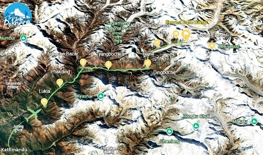
If you are willing to witness the world’s tallest peak, understanding the Everest Base Camp Map is the first and most important step to reach there. The Everest Base Camp trek map illustrates a complete, detailed path through the Khumbu region, guiding trekkers across the stunning landscapes, ancient monasteries, and world-famous mountain viewpoints.
Every section of the Everest Base Camp trekking map has a tale of adventure, culture, and the sheer majesty of the Himalayas. As a beginner trekker or as a seasoned old-timer, knowing the path and elevation is the key to a successful and enjoyable outing.
Overview of the Everest Base Camp Trek
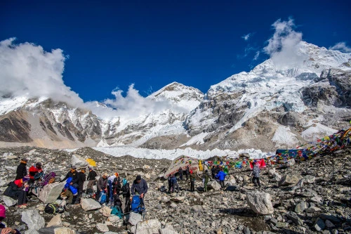
Everest Base Camp Trek is one of the world's most legendary treks, taking you deep into the heart of Nepal's Khumbu district, ancestral home of the legendary Sherpa people and the world's highest mountains. This legendary EBC trek follows old mountain trails through lush valleys, long suspension bridges, and traditional Sherpa villages to reach one of the most popular base camps in the world, the iconic Everest Base Camp (5,364 m) at the foot of the world’s tallest mountain, Mount Everest (8,848.86 m).
Covering approximately 130 kilometers (round trip), the trek takes 12-14 days to complete, according to the trek itinerary and acclimatization plan. Beginning your journey with a thrilling flight from Kathmandu to Lukla, the trek continues passing through several raw and untouched sites of the Everest Region, including Namche Bazaar, Tengboche, Dingboche, Lobuche, and Gorak Shep, with the life-lasting memories of the views of Everest, Lhotse, Nuptse, Ama Dablam, Lobuche, and other Himalayan mountain giants.
The Everest Base Camp trekking route is not just a walking adventure but a unique blend of adventure, culture, and nature. Along the journey, you will get plenty of opportunities to enjoy Sherpa hospitality, centuries-old monasteries, and landscapes that range from thick rhododendron forests to glacial rocky land. Despite its high elevation, the trek is reachable for most people with moderate fitness and proper preparation.
At its peak, Kala Patthar (5,545 m), the trekkers are treated to one of the finest panoramic views of Mount Everest and the surrounding Himalayas, an experience more than once in a lifetime.
Understanding the Everest Base Camp Trek Map
The trekking trail map of Everest Base Camp begins with a short and thrilling flight from Kathmandu to Lukla, the gateway to the Everest region. It then follows a track that winds its way through alpine forests, prayer flag-dotted bridges, and Sherpa villages to the legendary base of Mount Everest (8,848.86 m).
Everest Base Camp Elevation and Altitude Overview
The Base Camp height of Everest is 5,364 meters or 17,598 feet above sea level. As you climb higher, the air gets thinner, and therefore it's essential to pace and incorporate acclimatization days.
The trek begins at Lukla (2,860 m) and slowly moves upwards towards the base camp. Shortness of breath is universal in most trekkers above 3,000 meters, and therefore it's essential to drink lots of water, climb slowly, and rest well.
Everest Base Camp Elevation Points to Watch Out For
-
Lukla – 2,860 m
-
Namche Bazaar – 3,440 m
-
Tengboche – 3,860 m
-
Dingboche – 4,410 m
-
Lobuche – 4,910 m
-
Everest Base Camp – 5,364 m
-
Kala Patthar – 5,545 m
Understanding these elevations on the Everest Base Camp map itinerary allows you to plan acclimatization days and avoid altitude sickness.
Digital and Paper Everest Base Camp Maps
While organizing your trek, it is vital to choose the right type of Everest Base Camp trail map to adhere to. Trekkers these days often make use of both paper and electronic maps to guide them on the right route through the journey.
1. Digital Maps
Present-day trekkers like to take advantage of smartphone apps such as Maps.me, AllTrails, and Gaia GPS. They allow you to download the Everest Base Camp trek map route for offline use, perfect for areas without internet or mobile signals. Computer maps display current GPS location, trail paths, elevation profiles, surrounding landmarks, and even options for alternative routes. They are compact, easy to access, and good enough for everyday navigation on the trek.
2. Paper Maps
A paper map is a definite requirement for every trekker. You can easily get them from your agency or buy them in Kathmandu, Lukla, or Namche Bazaar before starting the trek. Having a paper map of the Everest Base Camp trekking trail provides a clean visual overview of the region with villages, rivers, contour lines, side trails, and elevations. It's also a great help with everyday route planning or monitoring progress during breaks.
Pro Tip: Carry both forms of maps along. Use your digital Everest Base Camp map for real-time tracking and your paper map as a backup plan and reference point, especially in areas with poor connectivity. The combination ensures accuracy, reliability, and peace of mind on your trek.
Tips for Using the Everest Base Camp Trek Map
Using good sense with the Everest Base Camp map will make your journey easier, safer, and more enjoyable. The following are some essential tips to help you walk the trail confidently:
-
Study Elevations: It is always best to refer to the altitude difference between two points before trekking. This helps you pace your walk and plan appropriate acclimatization.
-
Mark Acclimatization Villages: Key stopovers like Namche Bazaar and Dingboche are crucial to acclimatize to high altitudes. Never skip these acclimatization stops.
-
Follow Landmarks: The route is marked with unique features like suspension bridges, chortens (Buddhist shrines), and mani walls. Use these as natural landmarks on your Everest Base Camp trail map.
-
Keep Track Offline: Internet access may be poor in the mountains. So, make sure to download your Everest Base Camp trek map offline before flying to Lukla.
-
Use Local Guidance: Even if you have a detailed map, hiring a guide guarantees security, reliability, and greater cultural insight into the Khumbu region.
These tips will help you use the Mt Everest Base Camp trek map more effectively, and you can therefore enjoy a hassle-free trek with the confidence of staying on the right trail.
Best Time to Use the Everest Base Camp Trail Map
Knowing the best time to trek to Mt Everest Base Camp is as important as being familiar with your Everest Base Camp trek map. Weather conditions in the Himalayas can go a long way in affecting visibility, safety, and navigation, and thus choosing the right season ensures a smoother trekking experience.
Spring (March–May):
Spring is one of the most popular seasons for trekking to EBC. Pleasant climate, blue skies, and blooming rhododendron forests provide colorful colors to the treks, and the trails are gorgeous. Clear and scenic vistas are the ideal time to utilize your Everest Base Camp map.
Autumn (September–November):
Autumn is considered to be the trekking season par excellence. Autumn offers stable weather, perfect mountain scenery, and enjoyable temperatures. The map of the Everest Base Camp trekking route will lead you over neat, snowless trails with good views of mountains like Everest, Lhotse, and Ama Dablam.
Winter (December–February):
While temperatures drop, the trails are less crowded, offering peaceful trekking conditions. With fewer folks around, you can enjoy a quieter experience, but be sure to check your Everest Base Camp trek route map for current paths, as snow may be covering some routes.
Monsoon (June–August):
Avoid trekking during the monsoon season. The trail becomes slippery from heavy rain, rivers swell, and mist hides the mountain views. Navigation is tricky even with a map because fog and landslides make it even more difficult.
Altitude Sickness and Acclimatization for the Everest Base Camp Trekking Route
Hiking to high elevations like the Everest Base Camp (5,364 m) makes your body adapt to lower air pressures and less oxygen. Altitude sickness, also known as Acute Mountain Sickness (AMS), is among the biggest challenges during such hiking. Knowing how to prevent and manage it by proper acclimatization is essential to trek safely and successfully.
What Causes Altitude Sickness?
Altitude sickness occurs when your body travels too high too quickly without enough time to acclimate to lower oxygen. Symptoms can appear as soon as 2,500 meters and may include:
-
Headache
-
Nausea or loss of appetite
-
Dizziness or light-headedness
-
Shortness of breath
-
Difficulty sleeping
-
Fatigue and weakness
If not treated, deteriorating symptoms can be followed by more serious problems like High Altitude Pulmonary Edema (HAPE) or High Altitude Cerebral Edema (HACE), for which an immediate descent and doctor's treatment are required.
Acclimatization Technique
Acclimatization is the gradual acclimation of your body to higher altitudes. The Everest Base Camp trekking route map has acclimatization days incorporated along the trek at key locations to reduce the risk of altitude sickness.
Below are some decent acclimatization tips for trekkers:
-
Ascend gradually: Avoid climbing more than 300–500 meters above sleeping altitude in one day after 3,000 m.
-
Rest days: Spend a night at Namche Bazaar (3,440 m) and Dingboche (4,410 m) as proposed in most of the itineraries.
-
Hydrate: Drink plenty of water and do not drink alcohol or smoke, as they dehydrate the body.
-
Sleep low, climb high: When you have a rest day, go higher and come down lower to sleep.
-
Eat plenty: Consume calorie-dense foods to maintain body and energy at high altitude.
Take medication if needed: Certain trekkers take Diamox (Acetazolamide) on a doctor's prescription to avoid AMS.
Identifying and Dealing with Symptoms
If you find yourself developing the symptoms of altitude sickness:
-
Come down immediately and rest.
-
Inform your guide of your guide and get monitored.
-
If the symptoms persist or worsen, descending to a lower altitude, dropping 500 m, can be a big plus.
-
Do not disregard the symptoms; going on is dangerous.
Acclimatization Breaks along the Everest Base Camp Trekking Trail
Two required acclimatization breaks are built into the Everest Base Camp trekking trail:
-
Namche Bazaar (Day 3): Normally has a short ascent to the Everest View Hotel (3,880 m) or Khumjung Village.
-
Dingboche (Day 6): Usually entails a climb to Nagarjun Hill (5,100 m) for unbeatable views and true altitude acclimatization.
Rest days such as these are important in allowing your body to adapt to the high altitude of Everest Base Camp, making your trekking experience safer and more enjoyable.
Final thoughts
The trek to one of the stunning locations of the earth with the Everest Base Camp map is not just about navigation; it's about how you can enhance your overall trekking experience. Whether you are using a paper or digital GPS map, it's crucial to understand the route, elevation, and landmarks, as it lets you trek with confidence and safety. Although the Everest Base Camp trek is clearly defined, the high elevation and isolated terrain need adequate planning, particularly for weather and acclimatization.
Before setting off, study your route carefully, note the elevation gains, and plan rest days at Namche Bazaar and Dingboche. The combination of the precision of digital maps with the reliability of paper maps makes the experience even better. With the right map, proper mindset, and respect for the mountains and Mother Nature, you can set out for one of the most rewarding adventures on Earth, a journey to the foot of the world’s highest peak, Mount Everest (8,848.86 m).
FAQs(Frequently Asked Questions)
-
Why is the map important for Everest Base Camp?
The Everest Base Camp map is very important during the EBC trek because it helps in navigation, figures out the key landmarks, and reaches the destination without losing the track.
-
Where can I find a reliable map for the Everest Base Camp trek?
You can get the Everest Base Camp trek map from your travel guide or agency. You can also purchase one in Kathmandu, Lukla, or Namche Bazaar.
-
Can a beginner do the Everest Base Camp Trek?
With proper fitness, courage, and preparation, a beginner can also complete the Everest Base Camp. However, it’s highly recommended to experience a short and easier trek.
-
How hard is it to climb to Everest Base Camp?
The trek difficulty of the EBC trek is moderate because it doesn't require technical climbing. However, it requires a good fitness level and proper preparation and planning.
-
Which route is best for Everest Base Camp?
The best route to the Mount Everest Base Camp depends on the individual's choice. However, the classic route with the flight to Lukla and then trekking to the Everest Base Camp, passing Phakding, Namche Bazaar, Tengboche, Dingboche, Lobuche, and Kala Patthar, is the most popular one.